Monday, November 23, 2009

Rock-climbing near Hutoupi

It has become a tradition for us that Thursday night is rock-climbing night. I teach an extra class in the evening after my regular teaching is over on Thursdays and as soon as I am able I race home to An-ping on our scooter so that I can make the quick transition to rock-climbing mode. In fact this is not really as dramatic as it sounds; it involves me changing clothes and helping Andrea to check that we've got everything we need. Then we usually meet our friends downstairs and scoot off together towards Hutoupi.

Very close to Hutoupi is an abandoned outdoor activity centre. This is where we climb our 'rocks'. Of course, they're not real rocks but instead we climb an artificial climbing wall covered in hand holds. The objective is to make our way from one side of the climbing wall (we usually start from the left) to the other side without touching the ground, relying only on whatever nooks, crannies, or crevices we can find on the wall for our hands and feet.


This activity seems to be really good for building upper body strength. I don't think we've ever managed to get all the way from the left end of the wall to the right end. Your arms get pretty tired pretty quickly when you're using them to move the rest of your body. As I said before, we usually go rock-climbing on Thursday nights and this means that we need to take our own lighting; the facility is abandoned and the only other lighting we get is from the moon or from street lights outside the facility. The photos in this post were taken on a weekend when we happened to be going to Hutoupi Lake (close by) and thought to make the most of being in the area and go for a climb.

In a scene reminiscent of Stallone's Cliffhanger John successfully negotiates a difficult corner and outsmarts John Lithgow (not shown in photo).


In this short movie I make it most of the way around the wall only to stop because a particular foothold became quite painful with most of my weight concentrated on it through a very small area of my foot.


John stretching after climbing.


This is me recovering after hurting my lower back. I hung by my hands for about thirty seconds thinking it would be good for my back, stretching it out and freeing up the vertebrae but, instead, as soon as I tried to put my weight back on it I experienced terrible pain as if nerves in my spinal column were being pinched between the edges of vertebrae. It was awful but not the first time in my life that I have hurt myself after trying to stretch my back. Perhaps I'm better off just leaving a consistent weight on it. I really hope that I don't suffer serious back problems when I get older.


Wednesday, November 11, 2009

River Tracing: Liangshan Waterfall near Majia Township


What is river tracing?  It basically involves following the course of a river, travelling upstream by walking, swimming, clambering over and up rocks and rocky outcrops and the occasional use of ropes to assist in ascending and descending where required.  River-tracing is called other things in other countries and it is very closely related to canyoning/canyoneering (Wikipedia reference).

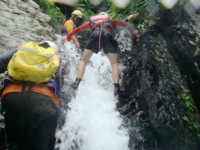
Back in July while Andrea's sister Erin was here we joined a river-tracing expedition upstream along part of a river in the vicinity of Majia township. The expedition had actually been initiated and arranged by somebody/somebodies at a school John used to work at and I think it was meant to be one of those extracurricular, getting-to-know-your-fellow-employees events.  I think everyone involved (apart from the two guides) were employees of, or otherwise connected in some way to John's former school.  And then there was us: Andrea, Erin, John, and me.

We, the four random tag-along foreigners, met up in our neighbourhood and then drove our scooters to the school.  After a wait of some twenty minutes everyone piled into the two buses parked in front of the school and we all headed off to Majia township in Pingtung county, south-east of Tainan.

We arrived in Majia and stopped in the carpark next to the Majia Visitor Centre, adjacent to the dirty canal that constitutes a (lower) part of the water-course that we would be tracing.  The next step involved getting suitably outfitted for scrambling over rocks and through water.  We all picked out a life-vest, helmet, and pair of gloves.  Our guides also got themselves ready and kitted-out.  Somehow we looked slightly ridiculous while our guides looked completely natural and professional.  Perhaps that was because they were wearing yellow.

 
The pre-river-trace group shot.  Everyone is excited, anticipating the imminent adventure and potential hazards.  I seem to be the only one without a helmet.  Oops.

 
A baptism of water; cold, cold water.  This is the first area of open water you come to after you walk from the carpark towards the falls.  We look unashamedly hopeless.  Hapless even.

 
A second baptism of water.  This time we were lowered, one at a time, by one of our guides into this narrow gully of which the water shoots out.  The point of this is that you get to ride the white water as it carries you away into the pool in the foreground.  The reality is that there are large rocks under the surface that you hit your lower-back and tailbone on, injuries that remain painful for weeks after the fact.  After this experience I became immediately cynical about the whole expedition and had to fight off the urge to complain incessantly about my tailbone.

 
Like an ill-trained troop of new-recruits we struggled to surmount small boulders lurking beneath the surface and fought to overcome uneven footing on the bottom of the riverbed.  Our unprofessionalism was hard to hide and my stoic coutenance rang hollow.  I was sore about my tailbone and wanted a nice hot coffee.

 
At this juncture, John was asked by the guide to position himself at the base of this small fall in order to help the other river-tracers surmount it and to cushion any falls or slips that might occur.  Practically, this involved John applying an upwards force to the body attempting the surmounting and I can still remember him doing his best not to touch anyone's bum.

 
This was our rock, an island in a stream of turbulence, a solid foundation from which we could contemplate the chaotic movement of the waters rushing by in their attempt to get from up to down as efficiently as possible.  This was our rock.

 
That was our rock.

 
An action shot: me making a flying leap at the water.  You can feel the tension and import of the moment.  It's moments like this one at which I think perhaps a career in acting and drama are not out of the question but very much a potent, unrealised certainty.  There's something very 'Stallone's Cliffhanger' about this.

 
Two sisters enjoy being able to be in the same place and time together.

 
Insert caption here.

 
I chose the most flattering shot of Andrea I could find.

 
After a slow and fairly relaxed slog up-river for a couple of hours it was time for luch and I was impressed when I realised that the extra bags a few of us had been carrying actually contained everything required to make lunch for the whole group.  When we had suited up back at the bus, one of the guides asked me if I could carry an extra bag on my back.  The bag contained two large lightweight metal drums or bowls.  I found out at lunch time that these were cooking pots and the guides prepared a kind of noodle soup in them.  Being alternately wet and drying out had started to get to me and I was on the verge of beginning to shiver when we stopped for lunch; a bowl of steaming hot noodle soup was a wonderful thing to have.

 
Adjacent to the picnic area was a small lake through which the river ran.  The water course entered the lake in a spectaular fashion, creating a waterfall on the far side.  A few of us tried jumping off the rocks into the exploding water.  Good fun.

 
The ascent to the final waterfall of our river-tracing and the highest point of the hike.  I don't know exactly which waterfall is Liangshan Falls but this might as well be it. 

 
Seasoned river-tracers all:
  Made their way to Liangshan Fall,
Bumps and scrapes were no deterants
Stolidly they fought the currents
Up outcrops and over boulders
(some with pots upon their shoulders)


Wednesday, October 28, 2009

Cycling from Tainan to camp at Wushantou Reservoir

The Wushantou Reservoir Scenic Area is famous for many reasons, few of which I appreciated before I started reading about it in preparation for writing this post and, having since educated myself as to the significance of the area... well, you decide.

Wushantou Reservoir is the linchpin of the Wushantou Reservoir Scenic Area, a part of the greater Siraya National Scenic Area north-east of Tainan. The lake behind the reservoir wall is sometimes called Coral Lake because from above it looks like ... well, coral.

The reservoir itself was constructed in the 1920s by the Japanese colonial administration of Taiwan. The engineer in charge of the project was one Yoichi Hatta, a graduate of Tokyo Imperial University in Japan.
Every year on May 8 a ceremony is held to honor Japanese engineer Yoichi Hatta (1886-1942) at his grave near Wushantou Reservoir. Those who solemnly pay their respects to "the father of the Chianan Irrigation Waterworks" amid copious offerings of flowers and fruits include both Chianan farmers and admirers who make the trip all the way from Japan. They keep coming year after year-even now, 66 years after Hatta's death.
The story of Yoichi Hatta, his life and death, the death of his wife, his renown for being fair and egalitarian, and the fondness with which he is still remembered today, all make for interesting reading and here is an article on the subject from Taiwan Panorama.

Wushantou Reservoir is right next to the township of Kuantien/Guantian (literally "tenanted farm"), famous for being the hometown of Taiwan's former president, Chen Shui-bian. This website provides lots of information about the town and it's most famous ex-resident.

The Wushantou area is also famous for its fields (ponds rather) of water caltrop. This caltrop is a kind of water chestnut (but unrelated to the water chestnut popular in Chinese cooking as it is done in the west). It is a "floating annual aquatic plant, growing in slow-moving water up to 5 meters deep, native to warm temperate parts of Eurasia and Africa." It has a distinctive shape and is called many things, including "moustache nut" by me. Interestingly, the water caltrop has been declared a noxious weed in some states of the United States and of Australia. [Wikipedia reference]

Just beyond the south-western side of the reservoir is the Tainan National University of the Arts. This university campus has a nice feel about it and every time we have been there we feel as though we could be in another country or place. We are drawn to the campus for another good reason: there is a 7-11 there and we don't know where else to find something to eat for breakfast.

The one other thing I want to point out is that within the grounds of the Wushantou Scenic Area is a replica of the Temple of Heaven (Tiantan) in Beijing. I think it's time to get lazy and copy a description from here:
The Temple of Heaven (Tian Tan) (天壇) at Wushantou is one of the biggest attractions there. The 'temple' is a recreation of the one in Beijing. However, this wooden Temple of Heaven is only 1/6th of the size of the actual temple; but it is still quite impressive and looks almost identical to the other. At times, the inside of the building may be open, but it was not during my visit. Supposedly, this Temple of Heaven, like the other, is made with no nails or mortar at all.
It's actually not very exciting but it is a nice-looking building to have around.

We left Tainan on a Saturday morning and headed north out of the city on a course through the fish farms. Living in An-ping as we do, heading north is the quickest way to get out of the city although you do find yourself in what sometimes feels like a bleak, empty, possibly post-apocalyptic landscape. But it does get you away from the over-stimulation of the city. Here's Andrea posing somewhere close to the coast while in the background the giant golden crab rears its giant golden claws. Beware the giant golden crab!

I enjoyed the beautiful day and let Andrea and John negotiate our route from here while a fisherman passes between their helmets. Note the colossal new highway in the background which breaks up the bleak landscape, for better or worse I am not sure.

To stop at at least one 7-11 during any journey in Taiwan is nigh on obligatory and inevitable. 7-11s differ from each other in the facilities they provide and the provision of public toilets becomes a particularly salient quality when cycling from town to town.

In yet another obscure small town a public monument depicts a bullock cart being helped along by three men. I suppose they are transporting rice. This is one of those many, many times at which I wish I could read Chinese.

At a seemingly unnecessarily large intersection for such a small, quiet town John and Andrea follow the road beneath a web of wires.

If the Sydney Opera House were able to mate simultaneously with a mosque and a Taiwanese temple and bear viable progeny, surely they would birth an architectural child resembling this bulding in the photo above. This place is awesome and exists in the middle of a lot of ... well, nothing much in particular. And the central figure of worship here could be Lao tzu or Confucius although I really have no idea. Yet another instance of me proving my ignorance because I cannot read Chinese.

The road to salvation has many branches and twists and turns. Presented with a choice of two heavenly raptures (the temple on the left, the toilets on the right), Andrea forwent salvation of the spiritual kind for salvation of the bowel kind and used the public amenities provided for the patrons of the temple. And doesn't she look like she has found a kind of inner peace?

When I took this picture I already knew what I was going to write about it:
(think Elton John ...)
That's where we meet
Me and you rendezvous
In the temple at the end of the street

Lunch. Typical Taiwanese fare down the road from the temple.

We finally reached the Wushantou area and cycled past the main gate towards the small suspension bridge we knew offered much more convenient access to the grassed area where we intended to camp. However, the bridge was closed and undergoing renovation work and so we were forced to return to the main gate. There, we discovered to our chagrin that there was an entry fee of NT$200 plus a camping fee of NT$200 per tent. Considering that the last time we camped here we paid nothing because we were ignorant of the park fees (having entered the park via the suspension bridge), we were a little indignant at having to pay up. Sometimes you just need a piece of flat grass but end up paying for facilities you don't need just so that you can own a piece of flat grass for the evening. Oh well, I guess it makes up for our free stay last time.

Setting up camp. John has aspirations to make his mark in the adult movie business and this brush with John the porn star scared me enough to want to sleep on the far side of our tent with Andrea between John and I.

After setting up camp we walked through the village adjacent to the Tainan National University of the Arts to get to the 7-11 on the university campus. The village streetscape bore evidence of its proximity to a hub of creativity and design. It was really nice to see some public art in the town.

Just a little further down the road the walls on either side of the road were being decorated. This kind of art imposed on a public space is something we don't normally see in Taiwan so it lent the place a special ambience.

We had dinner at the 7-11 and managed to catch the end of the sunset when we moved upstairs onto the roof of the building where somebody had thought to provide a table and chairs. Afterwards we walked back to the campsite although we took the long and scenic route. Above: The temple of heaven is broken up into pieces as a reflection in the windows of an adjacent building. That seems fitting as the temple itself is a mere reflection of the real temple of heaven in Beijing.

We had a terrible time trying to sleep that night. It was still very warm and humid which is alright if there is any breeze but on this particular night the air was as still as the breath of a corpse. There was no movement of the air at all and we sweated on top of our sleeping bags. The humidity sapped our resilience. It was awful. And shortly after we did finally get to sleep we were awoken by a voice with a flashlight speaking Chinese. It turned out to be one of the park attendants collecting tent fees.

___________________________________

The next morning was a straightforward matter of packing up, showering, stopping at the 7-11 for a few breakfast snacks, and starting back for Tainan although this time we were taking the more direct route. On the way out we stopped for one last survey of the reservoir from atop the dam wall. Living as we do in Tainan, it is somehow comforting to comprehend a vista consisting almost entirely of hills, trees, and water, and, if you look closely ...

... someone cultivating their own small piece of peace of mind.

Monday, October 19, 2009

Taichung Marathon 2009

On October 3rd we headed north on the fast train (not the High Speed Rail train, just the fast train) to the city of Taichung for the Taichung Boulevard International Marathon (TBIM). Taichung is the third-largest city in Taiwan, followed by our own Tainan in fourth place. As usual, I ran the ten-kilometre course while Andrea and John ran the twenty-one-kilometre course. All the marathons we attend in Taiwan are organized and coordinated by the Chinese Taipei Road Running Association (CTRRA).

We found a decent cheap hotel a block or two away from the train station and made ourselves comfortable. Luckily the starting area for the marathon was only a few blocks away from the hotel and train station which saved us a lot of trouble. Marathons usually kick off very early in the day; you often wake up to the sound of your alarm clock in your hotel room while it is still dark outside. Being able to walk from your accommodation to the marathon starting-area on the morning of the race saves you a lot of trouble and time: you don't want to be relying on buses or trains; you just want to know that you can get there on time and without much effort.

After securing a hotel room we had to go to the temporary TBIM race station to pick up our 'package'. This package almost always includes a shirt printed for the event, a bib with your race number on it (you pin it to your shirt), an electronic ID chip (for marking your time as you pass through checkpoints along the race course), and an assortment of information relating to the marathon.

After a teppanyaki dinner not far from the TBIM race station we headed back to our hotel to try to get a good night's sleep before the big race.

What should have been a restful slumber consolidating our energies for the marathon was marred by at least two earth tremors, a series of attempts to control the temperature in the room (AC on, AC off, AC on, AC off ...), and several bathroom breaks. We awoke very early in the dark to the sound of my alarm clock, well aware that we hadn't slept very well. But after making the necessary preparations and getting out of the hotel room we were walking towards the marathon start area and feeling just a little excited about the whole thing. It was a beautiful morning to be in.

This is what you see waiting for you as you are about to cross the finish line.

Here are Andrea and John at the end of their 21km run. Andrea is keen to point out that the time given on the electronic clock attached to the finishing gate in the photo is the length of time since the race started. Our own race times depend on when our electronic chips (attached to our shoes) passed over the starting line. So although the clock in the photo displays a time of 2hrs 11m John and Andrea ran a time several minutes faster than that.

Upon crossing the finishing line John and Andrea made a beeline (whatever that is) straight for the water. I only ran 10km so I finished much earlier than both of them. It also meant that I didn't get a Super Supau towel like the one draped over Andrea's shoulder and the shoulders of dozens of other runners in the park.

John and Andrea do their stretching after rehydrating themselves. This web site says that, "If you do choose to stretch after you run, you should wait 30-45 minutes after you stop running to do so" while this web site says that, "Waiting 30 to 40 minutes later after your fatigued and tight muscles have cooled down (especially after long or fast-paced workouts) increases your chances of causing injury". I think John and Andrea do theirs ten or 15 minutes after they stop running so that's probably a good compromise.

After taking a taxi back to the hotel we discovered one of the cable channels playing the original Terminator and so we relaxed on our beds while Arnold Schwarzenegger chased Linda Hamilton all over the place. She ran quite a bit faster than we did.

Wednesday, October 7, 2009

Alishan, where you can kiss the clouds

Alishan was a place we had been interested in visiting for a long time but had never really gotten around to. The occasion of Erin's (Andrea's sister) stay with us mandated for getting up into the mountains. We live very close to the coast and so showing Erin the beach here was easy. But we couldn't let Erin leave the country without experiencing Taiwan at elevations greater than 100 metres above sea level, especially not when mountains are so central to the character of Taiwanese geography and at the heart of conceptions of Taiwan in general.

I've circled Alishan on the map above. To say that we went to Alishan is actually pretty vague and requires a bit of clarification. Alishan could refer to: A) The Alishan mountain range ("Alishan" in Chinese literally means "Ali Mountain"); B) The Alishan National Scenic Area, which is like a national park; or C) The township of Alishan. We caught a bus from Chiayi to Alishan township up in the mountains. The scenery on the way up was a wonderful reprieve from the flatness of Tainan.

And when we got to the top we found beautiful mountain vistas, cool fresh air, a different range of flora and fauna, and ... Starbucks. And a giant car park. Oh well, it wasn't a great surprise, just a disappointing inclusion within a beautiful setting.

We had booked our accommodation before we left Tainan and after a couple of queries we managed to locate our hotel down the hill from the main car park. Our room was fresh and light and didn't smell of stale cigarette smoke. Incredibly, the temperature was cool enough that we could lie under heavy quilts and feel very comfortable. Back in Tainan we would have been sleeping on top of our beds with the fan blowing on us all night. The temperature up here in the mountains had the effect of rapidly energizing us, or so I found.

We left our hotel room to do a bit of scouting about before the day's end but first we needed some nourishment, and what better place to find nutritious nourishment than the local 7-11. We consumed some nourishing drinks, pumpkin seeds, and baked snacks which fortified us against the demanding ramble that was to follow.

I think the wall upon which this mosaic resides is part of the wall that defines the boundary between the township and the National Scenic Area proper. We had passed through a checkpoint and paid an entry fee for the national park on the way up in the bus. Erin and Andrea could be sisters in this photo. I guess that's not as surprising as the implication that they might not be sisters in other photos.

We found our way to one of the two Giant Trees Trails within the park. These trails take the pedestrian sightseer through some magnificent stands of very tall trees, the cypress being notable among these. During the Japanese occupation of Taiwan from 1895-1945 the Japanese constructed a railway line from Chiayi up to the Alishan range to make logging of the cypress here feasible. Today the same railway line is famous as the Alishan Forest Railway, the red engine of which has become synonymous with Alishan and appears on all manner of related advertising and paraphernalia. The walk trail was fantastic. It was so refreshing to be among such tall trees and the air smelled of living things.

Erin and I stand in a shaft of sunlight that cuts its way through the blanket of shadow covering almost everything at ground level. This felt like a real forest.

On our walk-about we took a path through a grove of cherry blossoms and found this view of the clouds smothering the mountains at the end of the day. It was a beautiful evening, a world away from Tainan.
____________________________________

The following morning we took the famous Alishan Forest Railway down the mountains to Chiayi. You pass through three climatic zones (some sources claim four zones) on the way down and there was a noticeable change in vegetation as the train descended. However, there was also a noticeable change in our opinion of the forest railway as we realised that it was quite loud, clunky, and not too comfortable. The whole journey from Alishan to Chiayi took some four hours (including the short hike from one rail line to another halfway down the mountain) and we were more than happy to alight at the end of the journey.

Inspiring views on the way down compensate for some of the discomfort of the old train.

The end of the line in Chiayi and relief for us all as we are able to experience the joy of walking again. You can see that famous engine behind us.

Our trip to Alishan really broke up our routines, both practical and psychological, and allowed us to exist in a very different space for a weekend. Andrea and I want to return to the area and hike the Fenqihu trail but there's no word yet on when the Forest Railway or the Fenqihu trail will reopen after being damaged by Typhoon Morakot.

A few links: Forestry Bureau site, really nice National Scenic Area site, the Wikipedia site.